Things to do in Matucana
The waterfalls, viewpoints and routes that make Matucana one of the closest nature getaways to Lima. For each place we tell you how to get there, the entrance, the difficulty and how much time to set aside. Unconfirmed routes are labelled as reference only.
Map
Only points with a confirmed location are marked. For waterfalls and lagoons with a reference route, coordinate with a local guide.
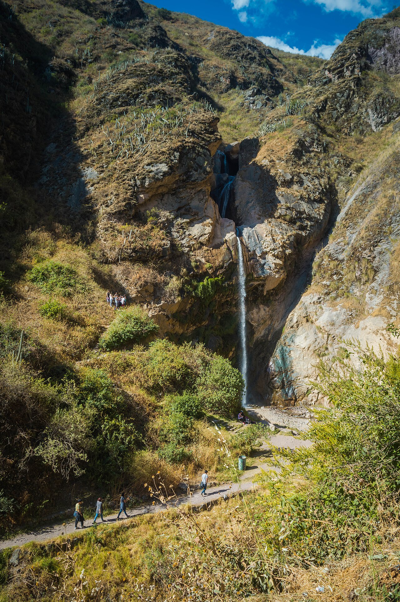
Antankallo Waterfall
Waterfall2,750 mS/5Easy to moderateHalf a day
The town's star attraction, at 2,750 m in the Chucumayo gorge. Along the way you'll see a rock forest with the 'lion's head' and 'face of Christ' formations, and the Tingo cascade, whose waters are considered medicinal for a refreshing dip. For a thrill there's a hanging bridge on the esplanade. Open year-round.
How to get there
You enter via the Cruz de los Olivos and cross the Antullay bridge; from Matucana it's about an hour and a half on foot (around 2.5 km of trail). You can drive up to the camping area and walk from there.
Challape Waterfall
Waterfall~2,250 mFreeEasy2 to 3 hours
An accessible waterfall in Huariquiña, only 800 metres from the village. Beside it stands a stone arch, the remains of an old irrigation channel that once watered the fields. Great for beginners and families thanks to its short walk.
How to get there
From Huariquiña (10 minutes before Matucana), a short walk away.
Huariquiña
Village & nature2,250 mFreeEasyHalf a day
At 2,250 m, on the left bank of the Rímac river, 10 minutes before reaching Matucana. Its charms include a pleasant climate, fruit trees and the mysterious Challape waterfall with its stone arch.
How to get there
On the Carretera Central, 10 minutes before Matucana coming from Lima.
Huillpa & El Cóndor Waterfall
Waterfall / Hamlet~2,030 mFreeModerate to hardFull day
Huillpa, in the hamlets of the Barrio Bajo farming community, has many natural wonders: waterfalls, rock formations and archaeological remains. The best known is the El Cóndor waterfall, at about 2,030 m. In the hamlet you can enjoy delicious fresh cheese and a very diverse agriculture.
How to get there
40 minutes from Matucana by vehicle. El Cóndor waterfall is about a 2-hour hike from the hamlet.
Marachanca
Hamlet & lagoons1,080 mFreeModerateFull day
A picturesque hamlet at 1,080 m, a land of flowers and farmers, with power and running water. It has several attractions: the Marachanca waterfall, the Twin Lagoons (Lagunas Gemelas) and the Puncho Punko archaeological site.
How to get there
From Matucana, along a dirt road that leads to the hamlets of Marachanca, Soca, Huillpa and Huallaque (about 1 h 30 min). From Marachanca to the Twin Lagoons, about 30 minutes.
Achacocha
High-altitude waterfalls3,715 mFree (guide recommended)HardFull day
At 3,715 m, with two waterfalls between 15 and 31.5 metres, fed by meltwater from the Arca lagoon. Nearby are shallow pools of waters considered medicinal, for a dip.
How to get there
A high-altitude destination; go with a local guide and acclimatise. Recommended in the dry season.
Ichoca & El Encuentro Waterfall
Village & waterfall2,780 mFreeEasy to moderateHalf a day
A peaceful village at about 2,780 m, 25 minutes from Matucana on the way to Antankallo, with small rest spots and a camping area. Its highlight is the El Encuentro waterfall, with three easy-to-reach drops, plus its arched bridge.
How to get there
25 minutes from Matucana, on the way to Antankallo. The Chacaya hamlet is nearby.
Route times to each destination
- Matucana – Antankallo1 h 30 min (~2.5 km on foot)
- Matucana – Huariquiña10 min
- Matucana – Ichoca25 min
- Matucana – Huillpa40 min by vehicle
- Matucana – Marachanca (hamlet)1 h 30 min
- Marachanca – Twin Lagoons30 min
- Huanraca – Marcahuay archaeological site30 min
Reference times from the official tourism board.
Tu marca puede aparecer aquí
Miles de personas usan esta herramienta cada mes. Muéstrate frente a ellas justo cuando te necesitan. Escríbeme y te paso el precio.
Escríbeme para el precioo escribe a reservas@geniuzgroup.com
Information gathered from the official tourism board of the Provincial Municipality of Huarochirí (Matucana) and public sources (Wikipedia, SENAMHI, gob.pe). Prices, hours, routes and dates may change; double-check anything critical before you travel and, for high-altitude routes, go with a local guide.