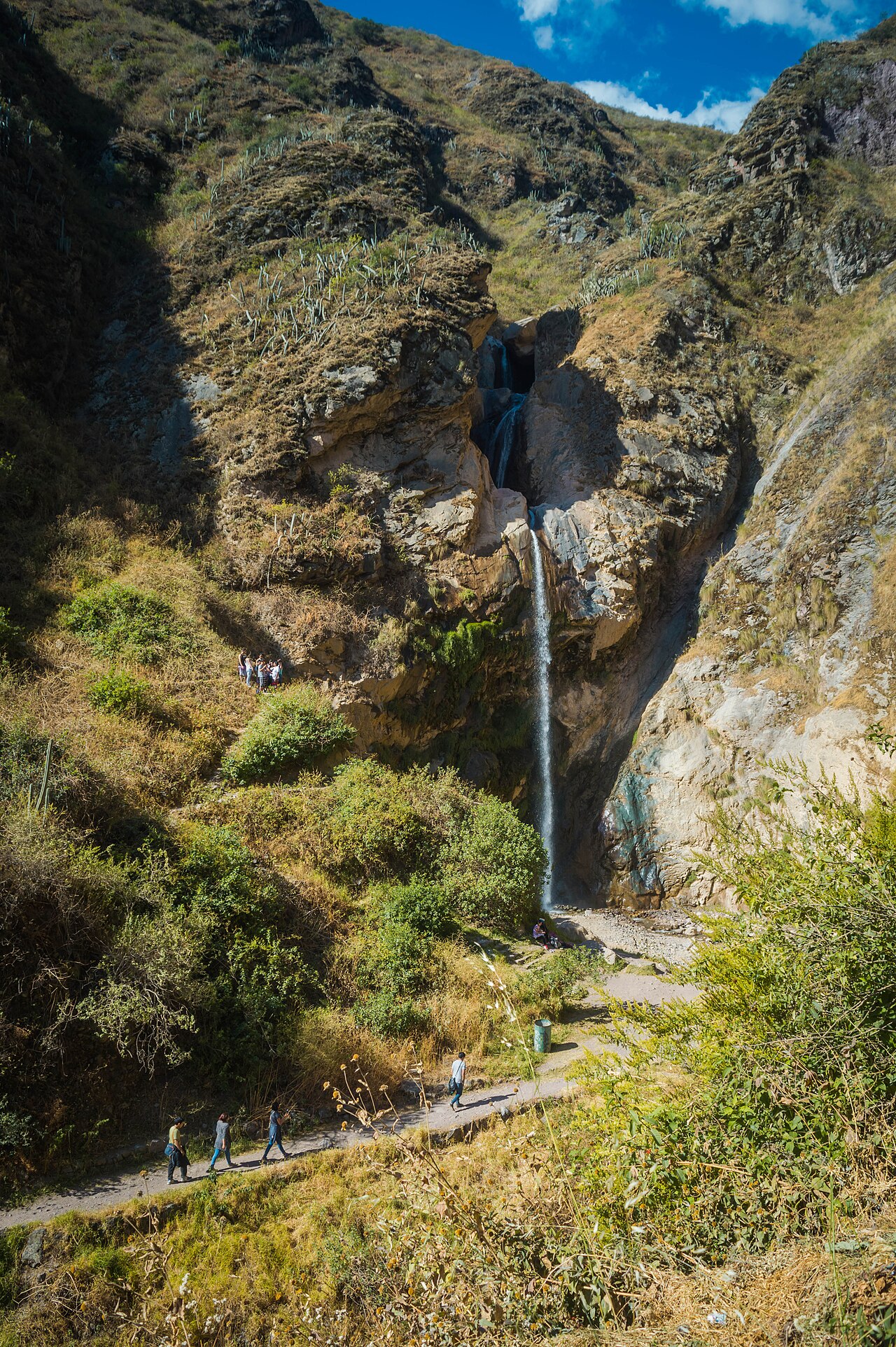
Matucana is the capital of Huarochirí Province, in the highlands of Lima, at Km 75 of the Carretera Central, on the upper Rímac river valley. About two hours from Lima, it is one of the closest nature getaways to the capital: waterfalls, archaeological sites, rock paintings, hidden lagoons and beautiful landscapes. Its jewel is the Antankallo waterfall, plus a rich local cuisine, its historic train station and its squares.
Why visit Matucana
- Waterfalls and nature just 2 hours from Lima — perfect for a weekend escape.
- Mild valley climate (about 27 °C by day), without the extreme altitude of other Andean spots.
- Hikes for every level, from short walks to high-altitude trekking.
- Real Andean food: stone-baked pachamanca, spicy cuy, trout and patasca.
Also worth seeing
San Juan Bautista Mother Church
With its new façade and two towers, plus its new Adoration chapel. Its altar holds the patron saint, John the Baptist.
Plaza Independencia
The district's main square, recently remodelled, with its fountain and a photo spot.
Plaza Grau
The oldest square in town, built in 1895; it held the country's second monument to Admiral Miguel Grau.
Alameda Centenario
At the town's entrance, to enjoy the Rímac river and the hills of the Chucumayo gorge on a quiet afternoon.
Railway Station
Behind Plaza Independencia; built in the late 1890s, its structure was brought from Holland.
Los Olivos Murals
On the way to the camping area, the house façades show hand-painted murals of the 32 districts of Huarochirí Province.
Los Establos
In the Los Olivos area, small stables raise cattle: fresh milk, cheese and manjar blanco.
Municipal Market
Five blocks from Plaza Independencia, on Jr. Lima: white cheeses, fresh meat, fruit and local produce.
Map of Matucana
Only points with a confirmed location are marked. For waterfalls and lagoons with reference-only routes, go with a local guide.
Getting there from Lima
The routes, transport and how much the trip costs in its two legs.
Where to eat and sleep
The local food and how to find a place to stay.
Festivals and weather
The festival calendar and the best time to visit.
Emergencies and contacts
Police, hospital, town hall and useful numbers.
Get around by mototaxi with MotoYA
Already in Matucana? Hail a mototaxi from wherever you are with MotoYA: you set the fare and pay by Yape or Plin, with no commission. And if you're a local mototaxi driver, join in and start working with visitors.
Businesses and services in Matucana
The town directory: guesthouses, restaurants, transport, guides and shops. Own a business in Matucana? List it for free so tourists and locals can find you.
From the community blog
See the blog →No posts yet. Do you know Matucana? Write the first one and share it with travellers.
Town festivals
San Juan & San Juanito patron festival
June 23–25The town's main festival: masses, processions, fireworks castles, music and bullfights.
Huarochirí Province anniversary
August 4Civic celebration of the province whose capital is Matucana.
Matucana district anniversary
September 4–5Celebrations for the district's anniversary.
Travellers' tips and experiences
Have you been to Matucana, or do you live here? Share a tip, a route or a recommendation for the next traveller.
No one has written yet. Be the first to leave your question or your story.
Frequently asked questions
How do I get to Matucana from Lima?
It's at Km 75 of the Carretera Central, about 2 hours by car. By public transport you do it in two legs through Chosica (a colectivo Lima–Chosica, then a bus Chosica–Matucana), roughly 3 to 4 hours; a one-way ticket is around S/15.50.
How much is the entrance to the Antankallo waterfall?
About S/5. It sits at 2,750 m in the Chucumayo gorge; it's roughly an hour and a half hike from Matucana, entering via the Cruz de los Olivos.
Can I swim in the waterfalls?
It depends on the season. From January to April the water comes down hard (high level) and it's not advisable to get in; from May to August it's medium (fine, but very cold); from September to December the level is low and the weather is pleasant — ideal for a dip.
How high is Matucana?
2,378 m (7,802 ft). It's a moderate highland altitude with a mild climate (about 27 °C by day and 13 °C at night); it usually doesn't cause the strong altitude sickness of places above 3,500 m.
When is the best time to visit?
April to December, per the official board. The dry season is better for walking; between January and March you'll see the waterfalls with more water, but the trails are slippery.
Is there somewhere to eat and sleep in Matucana?
Yes, there are guesthouses and country restaurants for the weekend visitor. In this site's directory the town's businesses list themselves so you can find them; if you own one, you can add it.
Tu marca puede aparecer aquí
Miles de personas usan esta herramienta cada mes. Muéstrate frente a ellas justo cuando te necesitan. Escríbeme y te paso el precio.
Escríbeme para el precioo escribe a reservas@geniuzgroup.com
Information gathered from the official tourism board of the Provincial Municipality of Huarochirí (Matucana) and public sources (Wikipedia, SENAMHI, gob.pe). Prices, hours, routes and dates may change; double-check anything critical before you travel and, for high-altitude routes, go with a local guide.